Tintagel to St Ives on the South West Coast Path is eight days of walking. It’s my favourite stretch of the South West Coast Path so far: an endless carousel of sandy beaches, secluded coves beneath rocky cliffs, little fishing villages with beach kiosks, all with the glittering blue sea on your right.
In this article, you’ll find a day-by-day summary of what you can expect on this eight-day hike from Tintagel to St Ives. Each day is between 10 and 14 miles of walking.
It’s not my intention to repeat the extremely helpful information you can find on the South West Coast Path website. This is an account of my own experience with tips I would have found useful to know before embarking on the hike from Tintagel to St Ives.
Getting to Tintagel
Tintagel is not especially easy to get to on public transport. I took trains from London to Okehampton (changing at Exeter), then a bus to Bude and another bus to Tintagel.
Taking a bus in Cornwall is an experience. You’ll wind down the narrow country roads, squeeze past hedges and wince when the unfazed bus driver encounters another bus head-on. The driver nonchalantly negotiates reversing back up the twisting road to allow the other to pass with mere inches to spare. Tourists grit their teeth as the other bus edges past the window. Cornish people don’t bat an eyelid.
If you have time, I recommend spending a day or two exploring Tintagel. Tintagel is reportedly where King Arthur was conceived, so Tintagel is steeped with Arthurian legend.

Day 1: Tintagel to Port Isaac (9 miles)
On the first day of your hike from Tintagel to St Ives, set out past Tintagel Castle, past the Norman church of St Materiana, and onto the South West Coast Path proper.
This first day is a bit of a baptism by fire. There’s no doubt that the section from Tintagel to Port Isaac is challenging. You’ll climb steep hills that feel endless, and then descend just as steeply on the other side, into a tiny village between the cliffs. Some of the terrain is difficult – at one point I had to beat my way through ferns which had grown over the path. At another point I found the narrow path blocked by cows.

The upside of this level of difficulty is that you’ll pretty much have the path to yourself. You can enjoy the dazzling views from the tops of the hills undisturbed. And you can easily keep track of how far you’ve come because you’ll be able to see the square tower of St Materiana on the cliff all day and even for days to come.
You’ll probably be relieved when you near Port Isaac. Port Isaac is a typical Cornish fishing village with whitewashed houses and a small beach. The sea as you approach the village is a bright turquoise and, depending on the time of year, you’ll be treated to an abundance of poppies and other wildflowers on the final stretch.

Day 2: Port Isaac to Padstow (12 miles)
Start day 2 of the hike with a strenuous stretch out of Port Isaac.
An early highlight of this section of the path is the Rumps – several large, spiky rocks protruding from the sea. It was quite windy when I was there so the Rumps were surrounded by white, crashing waves. Quite a dramatic sight!

You’ll be pleased to hear that the path becomes easier as the day goes on. The last part of the journey is a ferry across the River Camel from Rock to Padstow.
Padstow is one of the larger towns in the area. This means that, if you visit Padstow in July or August, you should expect it to be busy. Not only is it an ideal place for a family summer holiday but it’s also on the Rick Stein map so foodies venture there in droves.
Day 3: Padstow to Porthcothan (13.5 miles)
You might be pleased to know that the stretch from Padstow to Porthcothan is relatively easy. It goes around a peninsula whose edge is made up almost entirely of sweeping sandy beaches, among them Mother Ivey’s Bay, Harlyn Bay and Constantine Bay.
Make sure you buy lunch and snacks in Padstow before you depart as you might struggle to find anything along the way other than the odd beach café (if it’s open). Then you have your choice of beaches for a picnic lunch!
Day 4: Porthcothan to Newquay (11 miles)
On day 4, the path between Porthcothan and Newquay continues the theme of beautiful beaches.
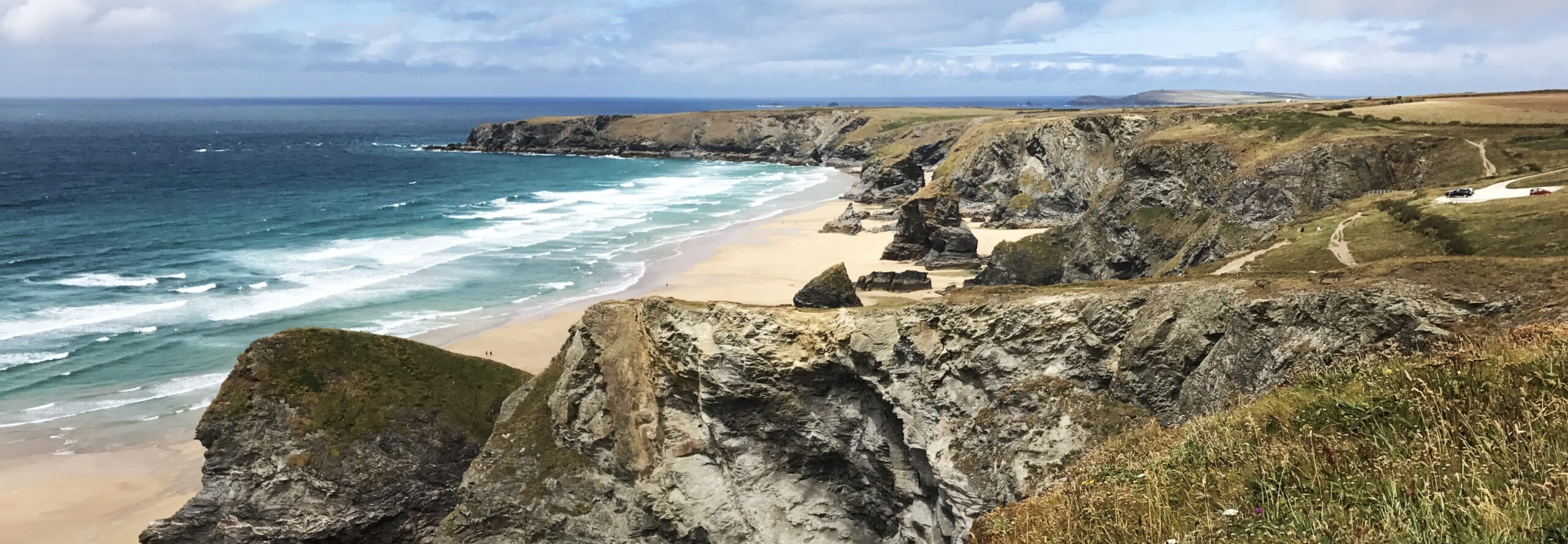
Almost straight out of Porthcothan you’ll reach one of my favourite beaches in northern Cornwall: Bedruthan Steps. Giant stacks of rocks stand along the beach, rockpools at their foot and crowds of mussels clinging to their edges. Unfortunately due to the risk of cliff falls you can’t go down onto the beach any more. But it’s still quite a sight from the cliff. It’s like a mini version of Australia’s Twelve Apostles.

A little way after Bedruthan Steps is Mawgan Porth, which has a lovely beach sheltered by cliffs on either side. I suggest stopping for lunch here as there aren’t many other places to stop between Mawgan Porth and Newquay.
Newquay is a good place for a rest day. It has a range of accommodation options, from hostels to nice hotels. Brits might be wary of Newquay as a hotspot for teenagers going on post-GCSE summer holidays but there are in fact nice areas and nice restaurants where you can avoid the rowdy crowds! Fistral Beach is famous for surfing and, even though I don’t surf, I enjoyed sitting up on the cliff marvelling at the surfers out to sea.
Day 5: Newquay to Perranporth (11 miles)
After a (hopefully) refreshing rest in Newquay, your first task on day 5 is to cross the tidal footbridge over the River Gannel. If possible, you’ll need to time this for when the tide is out. Otherwise you’ll have to go all the way round!
Once you’re on the other side, this is another day of iconic Cornish beaches including Polly Joke and Holywell Bay. But the best of all is at Perranporth: three miles of sand backed by sand dunes, with natural bathing pools. Perranporth Beach is my favourite beach in all of Cornwall so far.
Day 6: Perranporth to Portreath (12 miles)
Day 6 only gets better: Perranporth to Portreath is my favourite section of the stretch from Tintagel to St Ives.
Firstly, along this part of the path you’ll see evidence of Cornwall’s historic tin mining industry at Wheal Coates. Tall stone chimneys stick up along the coastline, a curious and unique sight.
Then right next to Wheal Coates is another of my favourite Cornish beaches: Chapel Porth. When I hiked past, its eastern end was deserted. The sand was pale gold, the sea shone an intense blue, and tiny yellow and purple flowers covered the hillside.

This is a fairly strenuous section with some steep descents and ascents in and out of coastal villages tucked between cliffs. But the reward for that is the beautiful scenery.
When you reach Portreath, you’ll find that it is a hub for holiday-goers. It has a large sandy beach, and ample amenities. You could consider resting here for a day or two.
Day 7: Portreath to Hayle (12 miles)
On day 7, once you’ve completed a steep section out of Portreath, most of the path between Portreath and Hayle is fairly easy-going, with stretches of it following hedged footpaths.
A highlight along this section is the whitewashed Godrevy Lighthouse on a small island off the coast at Godrevy Point. Godrevy Lighthouse was reportedly the inspiration for Virginia Woolf’s To the Lighthouse.

When you reach Hayle, you’ll be treated to more extensive sandy beaches. Hayle is on the train line so you’ll feel slightly better-connected than you have been for a few days!
Day 8: Hayle to St Ives (6 miles)
Now you’re on the home strait. Hayle to St Ives is a short stretch – only six fairly easy miles.
The final approach to St Ives takes you along a wide wooded path from which you can see the sparkling turquoise waters of Carbis Bay through the trees. And then you’ve made it all the way from Tintagel to St Ives!

A few days in St Ives
I definitely recommend staying a couple of days in St Ives. It’s an artsy town, as many seaside towns seem to be. Tate St Ives is well worth a visit.
Outdoors, get takeaway fish and chips and enjoy them on a bench overlooking the harbour. But watch out for the seagulls which are some of the biggest I’ve ever seen!
You can also walk up to St Ives Head and St Nicholas’ Church. From here you can see both of St Ives’ main beaches, either side of the St Ives peninsula. St Ives’ beaches are both large and sandy, with clear blue waters.
You can take a bus from St Ives around the very end of Cornwall to Land’s End. I don’t especially recommend Land’s End as it’s touristy and, if I may say so, a bit tacky. But the coastline is absolutely gorgeous.
Shortening the hike
If you don’t have eight days, you could hike from Tintagel to Padstow or Padstow to Newquay (both two days) or from Tintagel to Newquay or Newquay to St Ives (both four days). Padstow, Newquay and St Ives are larger towns so it would be easier to get to and from there than from any of the smaller villages along the way.
Before or after Tintagel to St Ives
I haven’t yet done any of the South West Coast Path before Tintagel. It’s 12 days of hiking, along the coasts of Somerset and northern Devon. This area tricky to get to on public transport but this probably means you’ll get the path to yourself!
The stretch after St Ives takes you around the very end of Cornwall, via Land’s End. It’s reportedly one of the hardest sections of the South West Coast Path. I’m yet to do that four-day stretch but I’ve been to many places along that way and I can verify that the scenery there is absolutely stunning.
After that stretch, I have done a long section of the south Cornwall coast: from Mousehole to Falmouth and then from Falmouth to Par. And I hope to do many more sections of the South West Coast Path!